This was a great hike that I had been wanting to get to for a long time. I probably should have checked the weather report beforehand because even though in the city it's in the 60's, it is much cooler up a canyon (It was on Oct 27th). I was dressed for a summer hike. My bad :-/ Buuuuut from what I read in Cosmo some women pay to go into freezing temps to burn calories, soooo it was like a free calorie burning session. Take that Cosmo and your expensive day spas! :D Aaannnyyyways, back to the hike. This hike is roughly 4.4 miles up Big Cottonwood Canyon in Salt Lake. Try not to get the Big and Little Cottonwoods mixed up. I've done this on more than one occasion. Although even if this happens, there's at least tons of hikes to do as an alternative. This hike is a popular one and there is a parking lot with restroom there. There is a trail head on the right, but that is marked and is clear it is not Blanche. Although I did that one and it was great. Much shorter though. I think it was around 5 miles roundtrip. The view for that hike is much better when there's a little snow on the mountains at the top so your view is nicer. I digress though. Back to Blanche trail. You want to take the cement path past the bathroom (note to self: the bathroom closes for winter season. As early as October. You've been warned). This paved way goes up roughly 1/3 of a mile and is parallel to a stream (which was more like a rapid when I was there). You will see the sign clearly marked on your right. About .15 miles past this sign is a cute bridge that's great for pics. There is a bench there too. It has a pretty good size incline so keep a good pace. It runs a little parallel in some parts with a stream. Even though you can't always see it, you can hear it. It's always nice to have that as a peaceful backdrop noise. There are several paths off the main trail that will lead to the stream. Just be careful when doing this. The ground was very damp and it was a little difficult to find my way back to the main trail. But there are just so many chances for some epic pics. Hard to pass those up. I had started the hike later in the afternoon, so there was no one else going up, but I did see a few groups coming down. Higher up the trail there started to be little patches of snow on the leaves or along the trail. Minimal though. For October that seemed awfully early in the season. Close to the top the trail gets covered by a slope of big rocks/small boulders. Please note that as soon as the path ends just climb the rocks a couple feet up and on the right is the trail again. It is parallel to the path you just came from. It's a switchback basically. I did not see this. Instead of immediately looking for the continuation of the trail I just wanted to see the view of Salt Lake. You can see it from this point very slight in-between the mountains to Big Cottonwood Canyon. I hiked across the rocks to get a better view, which led me away from the trail I needed to continue on. I ended up not being able to see the path and kept looking around. It seemed like there might be a trail at the top of the rocks so I hiked up there. Great view again, but for sure did not lead to a trail. However, I made my own trail. I could see where I needed to get to, so I tried to follow that. Then I got to a ravine (not sure I spelled that right but you know what I mean :-/). This was super steep and slippery. It was all loose rock and dirt. I knew I needed to take this down and it would lead me close to the proper path. Soooo, I made the best of the situation and dirt skied down. I was able to slide down with only stopping once my ankles were buried in the dirt and rocks. It was really fun, but I wish I had trekking poles to have had a smoother ride :) This led me to a spot that I could see would lead me back to the trail. I could hear people coming down, which is always a good sign when you're kinda lost and rollin solo. I got back to the trail and finished my journey up. However, this wasn't the last of my wandering off adventures for the day. There got to be a little more snow coverage, but still not much. Then I finally made it to the lake. It was beautiful. Not the most beautiful of ones I've been to in the canyon, but definitely worth the hike to. It was getting though and I was in little shorts with only a very light jacket on, so I needed to hurry and get pics. However, I heard a waterfall, so of course I went to go look for it. It was south of the lake. There were many skinny trails through brush, so you just kinda pick one cuz they all lead to the same place. I found a wimpy but pretty little fall. Next to it is a giant rock that looked like it had a great view. Of course I hiked up it. The view to Salt Lake and Blanche Lake would've been awesome, but unfortunately there were trees blocking the it. It seems that south of this though there is another mountain that you can continue on and up. Had I more time I would've searched it out. Getting down I decided to check out the waterfall. There were icicles along the green moss on the falls. It was gorgeous. I hiked down the falls. It was getting very cold at that point and there was still so much to explore. I carefully got down (easier said than done. Note to self: don't hike down the actual side of the waterfall especially when there is water and ice and slippery moss). I ran back to the lake to get some amazing shots. However, there are just so many spots to take pics. Make sure you allot yourself plenty of time to hangout here. There was so much to see. After the last group left, I decided I should probably stop taking pics and head out. This time i was going to try to run down since the sun was going down and the temps were really dropping. By this time it was probably in the low 30's. I ran down as much as I could. Passed several groups which was reassuring to know I wasn't the only one out there. I saw a deer at one point, but it quickly ran once it saw me. It was alone. If you trail run you know to keep your eyes down to focus on the obstacles such as rocks, roots, water, steepness, etc. I've had a tendency to twist my ankle on many occasions, and slip almost losing my balance on many more, but this day my luck ended. Right as I was about 100 feet from the bridge I happened to look up because something the caught my peripheral view. There was a couple standing on the bridge. It caught me off guard and just then my foot hit a rock and I biffed it so hard. It was pretty steep and lose dirt so I skid a little bit. My shorts were pretty short and exposed my whole leg, therefore my leg had no protection. The only good thing was that my legs had actually almost gone numb, so I couldn't feel the pain (which later I would get the feeling back, and ohhhh was I missing the coldness right about then. Ouchy! ) My leg had dirt inside my skin with blood running down my upper thigh and under my knee and on my shin. It was not pretty. My left arm got a little broken skin and just a bad bruise. Amazing how my light jacket helped save skin from falling off. Well, trying not to look like a complete idiot I just gimped down to the bridge and past the people hoping they wouldn't notice blood dripping down my hurt, dirt infused leg. At least at this point it was rocky so I had to take it slow. Then I got back to the cement path at the trailhead. This is when I decided I needed to get back to the car to clean up as fast as I could so I could stop the blood. I ran back to the car (again, the numbness from it being so cold definitely was to my advantage at this point). I got all cleaned up (not after my car got a nice permanent blood stain on the freshly shampoo'd tan seats). I'm surprised with all my hiking and trail running that this hadn't happened sooner. Well here I am close to 2 months later and I still have huge scars on my thigh and shin. I like my "war wounds" though. They make me proud. Nature's tattoos for me :)
This is a hike I would for sure recommend. It's always nice hiking up to a lake especially one that has views of other even taller peaks as well as of the city. It is hikeable through October with clean trails. Not too many people, however I left around 130 on a Monday, so I'm sure that's not a busy time anyways. Make sure you remember where the trail is, though, when you get to all those big rocks. It's great to out on them and explore some, but just make sure you know where the connecting trail is first. Then again, sliding down the loose rocks was for sure a highlight :) Have lots of time and make sure there's plenty of room on your camera :)
My phone died .3 miles from the end so my mileage was roughly 7.5 roundtrip. However, this included me hiking a little past the lake and around. I found it to be an advanced hike, like an 8-8.5. It took me roughly 3 1/2 hours to do…and that includes getting lost, taking lots of pics, and bailing :-O Not sure the rest of my stats, but I'll post the internets stats.
Internet stats:
* 6.1 miles roundtrip
* 2,580 elevation gain
* 8,920 ft elevation at lake
* 4.5 hours
* Extremely Difficult
 |
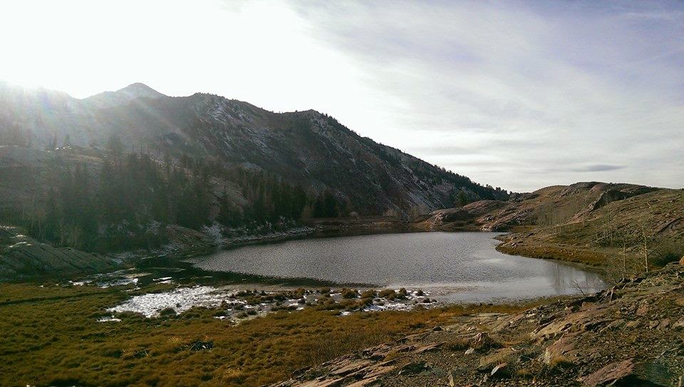
| View to SLC from the lake |
 |
Along the paved path about 1/3 miles up
you'll see this sign. Although my stats differ
from this sign. I did roughly 7.5 miles roundtrip.
It was at least 3.2 to lake, not 2.8. Buuuut still a helpful
sign nonetheless :) |
 |
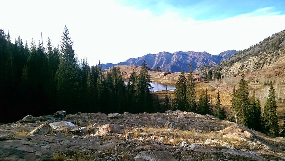
From the rock pile that covered the
trail, this is the view of SLC. |
 |
Little stream along beginning of trail.
 |
A little glimpse of how deep my feet
were when sliding down the ravine.
So much fun :) |
|
 |
| The first patch of snow on the trail. About 2.5 miles into the hike. |
 |
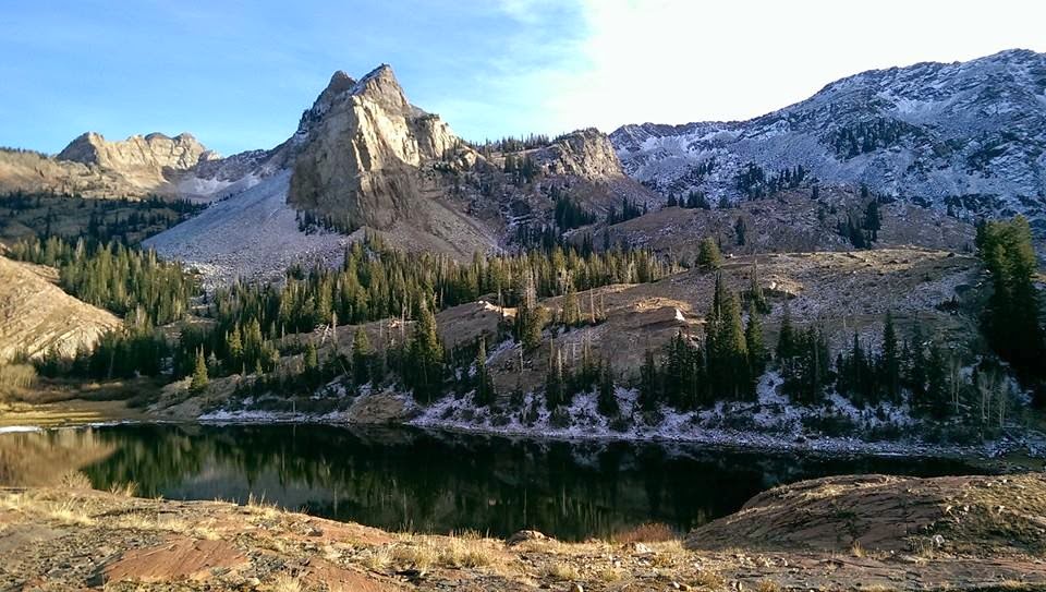
Amazing view and beautiful lake reflection. I think from this trail, you can continue
hiking to the top of this peak.
|
 |
From the highest point I climbed this was the view. The
trees are blocking the view of Salt Lake, but it's still pretty. |
 |
| The mix of seasons are depicted here. I love it. So beautiful! |
 |
| Lake Blanche |
 |
| Creek along the way. |
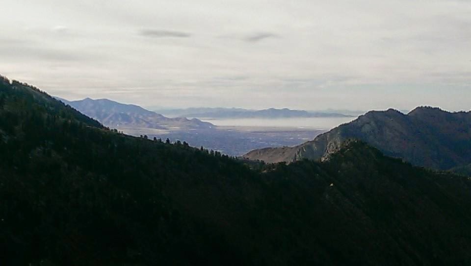 |
View from highest point on north end of lake. Overlooks
Salt Lake. The dark part is actually a forest of green trees.
It was unreal. |
 |
The little waterfall that I had heard
from the lake, so I went to see.
Ended up not really being much of
a waterfall at all. |
 |
| Beautiful reflection |
 |
When I got lost from the rocks this is where I thought I saw a
trail. So I hiked up to it at the top of the rocks. This is what
led me to the rocky ravine where I knew I had taken a wrong turn :-/ |
 |
| These trees with the blue sky and white clouds were awesome! |
 |
| I love these two trees twisted together. |
 |
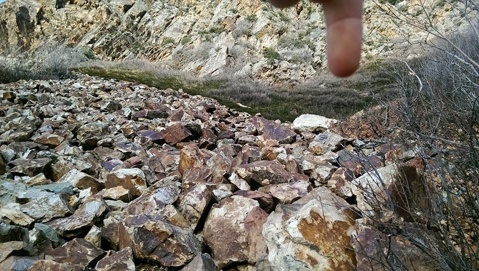
You can see on the right the trail. That is where I came from.
I'm pointing to where the trail continues. It is very close and
runs parallel. It's a switchback. |
 |
| So excited when I saw the snow capped bushes. |
 |
Climbing down the waterfall I saw this.
It was so bright green in person. The
water was super cold. However, it formed
really cool looking icicles. |
 |
After much clean up, this was the shin
aftermath from my fall. |
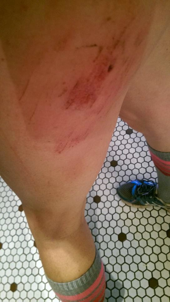 |
This one reminds me to wear longer
shorts when I hike. It was quite a mess
even after I cleaned it up. Both cuts have
left permanent scars or what I call my
"hiking war wounds" aka nature's tattoos :) |