I will be posting later this week about my White Pine Lake hike. For now though, please go to my Facebook page and like it so you can get updates, new pics, hiking groups, and much more :)
https://www.facebook.com/bettisblogofhikes.
Keep checking in. I'll post on FB when I update my blog.
Mahalo!
Monday, September 15, 2014
Thursday, September 4, 2014
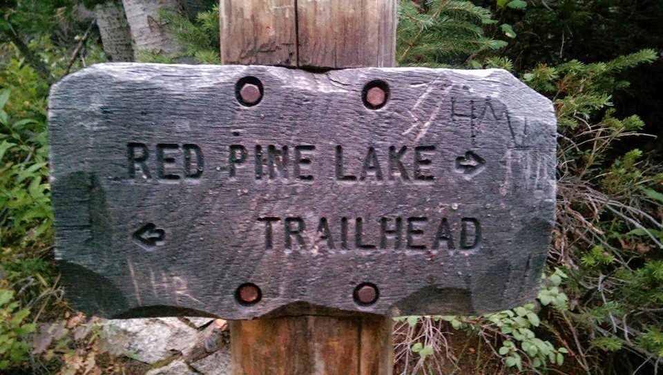
Red Pine Lake-Lower
It's been waaaaaay too long since I hiked. Almost a month. I'd like to blame insane amounts of homework and finals for that. After all that stress, I needed to get out. After going to Park City Parade of Homes, I had a few hours before the sun went down…or so I thought. I chose to go to Red Pine because White Pine was an extra couple miles and I knew I would run out of daylight.
I've been to this trail before. I actually went to do to Red Pine, but switched to White. This is when I first moved back here from Hawaii…and let me tell you what a shocker it was to see feet of snow instead of a trail. The trailhead is the same for both hikes, however 1 mile up, it splits. The first time I went the Ride Pine trail was completely covered with snow so unless you knew you where you were going, there was no way to see it. I did about 2.5 miles in of the 4 for White. Lost the trail deep in the mountains. Rollin solo, so I figured better safe than sorry and turned around.
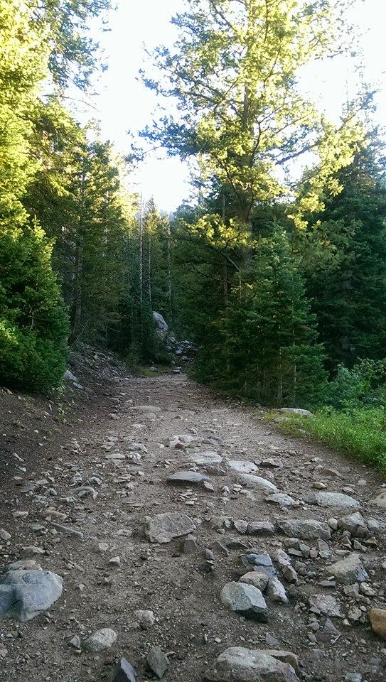
The trail looked completely different this time around. There was actually dirt on the ground instead of tons of snow that you sink into with every step (I wore running shoes too…which are not conducive for hiking on snow). At the mile mark where the trail splits, there's a beautiful rushing creek. There's a bridge that goes over it. Great spot for pics. The trail goes up at a steady incline. Beautiful views to the city at one point. Theeeeennnn it starts to get a little steeper. At first I figured I could handle it. Slowed my pace a bit, but it was doable. Eventually you get to a second bridge. Do NOT go across the bridge if you want to reach the lake. I'm not sure where the bridge goes to, buuuut one day soon I'll find out :) Keep going on the trail. At this point though, there's water, like a small creek, that's going down the trail. If you have thick shoes on you'll be fine. If you're in running shoes like mua, then you're doing some mini rock jumping. I ran into 2 older ladies right here. They didn't know where the bridge went to. They were however very concerned about it being so late and I was still hiking up. They warned me it gets steep. Ya sure…steep like what I just did? Oh I got this. Boy…they weren't kidding. It climbed awfully fast. I had to take a couple breaks for a minute. Even had I been more in shape, I probably still would have had to rest for a minute. I ran into the ladies at 2.5 miles in. The trailhead says it's 3 miles. So I figured half a mile of this incline (less than that actually cuz it wasn't super steep the whole half mile). Well not to burst your bubble, but it was NOT 3 miles up. It was closer to 3.2-3.3. I was so tired and worn out that I was getting worried I wouldn't get there. It was getting dark. Note to self: don't start 6.5 mile hikes at 6:30pm. It's not summer…sun goes down earlier than 9:30 :-/ Finally I could hear water running. I found the lake. It was beautiful. I wanted to walk around it, but it was getting too dark. On the south side of it is a creek. There's a long, short rock wall that runs parallel. I walked along that. Then as I was looking at the mountain in the distance, I noticed that about 100 feet away were around a dozen deer. A couple even had the big antlers. I had already gotten scared from one on the trail that was mere feet away from me. I didn't notice it until it ran up the hill a little ways. However, it stayed close and didn't run off as I passed by it. Seeing deer is always fun.
From this point you can walk around the lake, or if you still have energy you can keep going to upper lake. The trail for this is on the north side. Follow that about a mile. I'll be going back to go up there. There was a group coming down when I was at the lake. It seems like a popular trail.
It was getting dark, so I headed down. It was so sad that the camera couldn't capture the amazing beauty. The lake reflecting the mountains, the flowing creek surrounded with deer and greenery, the last of the daylight dancing on the mountain tops showing off the stunning fall colors of orange, yellow, red, and variety of greens. I couldn't capture it, but I sure can try to describe it ;) Going down was tricky. Not at first. However, the initial decent is steep so you have to take your time. Between the cold and steepness, my knees were not happy with me (thank you arthritis). I tried to trail run down in areas that were smoother and not so steep. It was definitely a race with the sun. However, the mountains were so beautiful, that you just want to stand there and watch nature. At the 2 mile mark (that's a guestimate) you can see the valley. All the lights were on and the sun had set, but the sky was still bright. It was a nice scene. Couldn't stay too long, so I headed back down. Around the 1 mile mark there was a backpacker heading up to camp. He's got much bigger kahunas that I, that's for sure. At this point I had to turn the flashlight on my phone. There were too many rocks and the trees hid the moonlight. There was a half moon that night and it was beautiful. I'm sure a full moon night would be even more beautiful. Finally I finished. Right before you hit the parking lot, you cross a bridge. I wasn't able to get pictures since it was too dark, but in daylight it's really beautiful.
I highly recommend this trail. You can get 3 amazing hikes from here…plus there's a bathroom at the trailhead :) To get there just keep going up little cottonwood. It's about 5.5 miles up, then after a right curve, you'll see a regular looking parking lot (not just the dirt and rocks type) with an open gate, on the right hand side. The trail is right behind the banos. There's also a map here. If you are out of shape, I don't recommend this hike, however, if you are intermediate then this is perfect. It's challenging at times, and you need to be patient, but it's well worth the climb. Bring your camera, because there will be great photo ops. Who knows…maybe some deer will even photo bomb you :)
My stats for the hike:
*6.7 miles roundtrip
*2,160 feet elevation gain
*1 hour 45 min
*Moderate to Advanced
*839 calories (really?! It seems like it should've been more :-/ )
Internet stats:
*6.5 miles roundtrip
*2,040 elevation gain
*9,620 elevation at lake
*Moderate
I've been to this trail before. I actually went to do to Red Pine, but switched to White. This is when I first moved back here from Hawaii…and let me tell you what a shocker it was to see feet of snow instead of a trail. The trailhead is the same for both hikes, however 1 mile up, it splits. The first time I went the Ride Pine trail was completely covered with snow so unless you knew you where you were going, there was no way to see it. I did about 2.5 miles in of the 4 for White. Lost the trail deep in the mountains. Rollin solo, so I figured better safe than sorry and turned around.
The trail looked completely different this time around. There was actually dirt on the ground instead of tons of snow that you sink into with every step (I wore running shoes too…which are not conducive for hiking on snow). At the mile mark where the trail splits, there's a beautiful rushing creek. There's a bridge that goes over it. Great spot for pics. The trail goes up at a steady incline. Beautiful views to the city at one point. Theeeeennnn it starts to get a little steeper. At first I figured I could handle it. Slowed my pace a bit, but it was doable. Eventually you get to a second bridge. Do NOT go across the bridge if you want to reach the lake. I'm not sure where the bridge goes to, buuuut one day soon I'll find out :) Keep going on the trail. At this point though, there's water, like a small creek, that's going down the trail. If you have thick shoes on you'll be fine. If you're in running shoes like mua, then you're doing some mini rock jumping. I ran into 2 older ladies right here. They didn't know where the bridge went to. They were however very concerned about it being so late and I was still hiking up. They warned me it gets steep. Ya sure…steep like what I just did? Oh I got this. Boy…they weren't kidding. It climbed awfully fast. I had to take a couple breaks for a minute. Even had I been more in shape, I probably still would have had to rest for a minute. I ran into the ladies at 2.5 miles in. The trailhead says it's 3 miles. So I figured half a mile of this incline (less than that actually cuz it wasn't super steep the whole half mile). Well not to burst your bubble, but it was NOT 3 miles up. It was closer to 3.2-3.3. I was so tired and worn out that I was getting worried I wouldn't get there. It was getting dark. Note to self: don't start 6.5 mile hikes at 6:30pm. It's not summer…sun goes down earlier than 9:30 :-/ Finally I could hear water running. I found the lake. It was beautiful. I wanted to walk around it, but it was getting too dark. On the south side of it is a creek. There's a long, short rock wall that runs parallel. I walked along that. Then as I was looking at the mountain in the distance, I noticed that about 100 feet away were around a dozen deer. A couple even had the big antlers. I had already gotten scared from one on the trail that was mere feet away from me. I didn't notice it until it ran up the hill a little ways. However, it stayed close and didn't run off as I passed by it. Seeing deer is always fun.
From this point you can walk around the lake, or if you still have energy you can keep going to upper lake. The trail for this is on the north side. Follow that about a mile. I'll be going back to go up there. There was a group coming down when I was at the lake. It seems like a popular trail.
It was getting dark, so I headed down. It was so sad that the camera couldn't capture the amazing beauty. The lake reflecting the mountains, the flowing creek surrounded with deer and greenery, the last of the daylight dancing on the mountain tops showing off the stunning fall colors of orange, yellow, red, and variety of greens. I couldn't capture it, but I sure can try to describe it ;) Going down was tricky. Not at first. However, the initial decent is steep so you have to take your time. Between the cold and steepness, my knees were not happy with me (thank you arthritis). I tried to trail run down in areas that were smoother and not so steep. It was definitely a race with the sun. However, the mountains were so beautiful, that you just want to stand there and watch nature. At the 2 mile mark (that's a guestimate) you can see the valley. All the lights were on and the sun had set, but the sky was still bright. It was a nice scene. Couldn't stay too long, so I headed back down. Around the 1 mile mark there was a backpacker heading up to camp. He's got much bigger kahunas that I, that's for sure. At this point I had to turn the flashlight on my phone. There were too many rocks and the trees hid the moonlight. There was a half moon that night and it was beautiful. I'm sure a full moon night would be even more beautiful. Finally I finished. Right before you hit the parking lot, you cross a bridge. I wasn't able to get pictures since it was too dark, but in daylight it's really beautiful.
I highly recommend this trail. You can get 3 amazing hikes from here…plus there's a bathroom at the trailhead :) To get there just keep going up little cottonwood. It's about 5.5 miles up, then after a right curve, you'll see a regular looking parking lot (not just the dirt and rocks type) with an open gate, on the right hand side. The trail is right behind the banos. There's also a map here. If you are out of shape, I don't recommend this hike, however, if you are intermediate then this is perfect. It's challenging at times, and you need to be patient, but it's well worth the climb. Bring your camera, because there will be great photo ops. Who knows…maybe some deer will even photo bomb you :)
My stats for the hike:
*6.7 miles roundtrip
*2,160 feet elevation gain
*1 hour 45 min
*Moderate to Advanced
*839 calories (really?! It seems like it should've been more :-/ )
Internet stats:
*6.5 miles roundtrip
*2,040 elevation gain
*9,620 elevation at lake
*Moderate
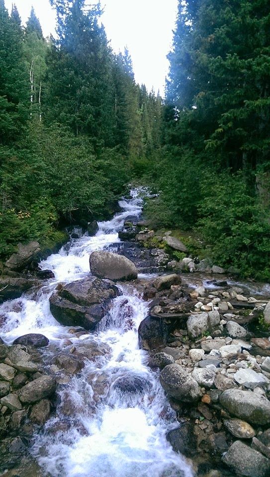 |
| One of the many beautiful creeks. |
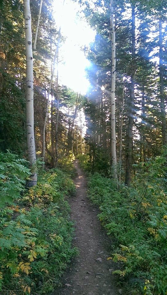 |
| Some part of the trail were great for runnign |
 |
| You can see the lake level has dropped |
 |
| Getting a little rocky (be careful if you trail run) |
 |
| This you'll see at about 2.5 miles up. |
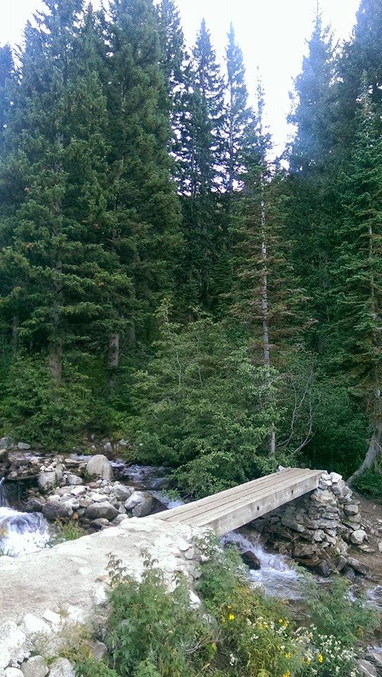 |
| The first bridge. Around 1 mile up. |
 |
| The steep incline begins… your endurance begins to end ;) |
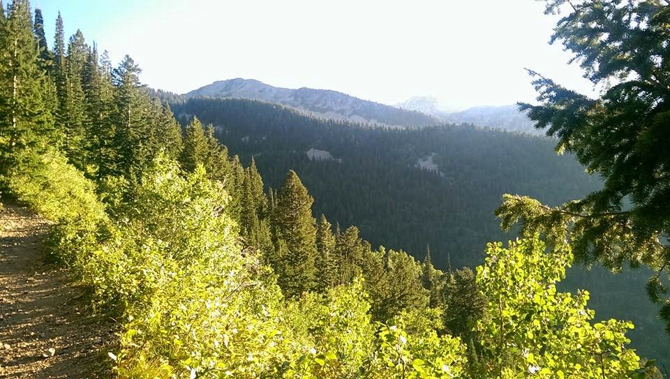 |
| One of the many beautiful lookouts to even more mountains. |
 |
| The bridge at 2.5 miles up. Where does it go??? |
 |
| The creek at the lake the runs by the rock wall (south of lake). |
 |
| Not so smart running down this in the dark :-/ |
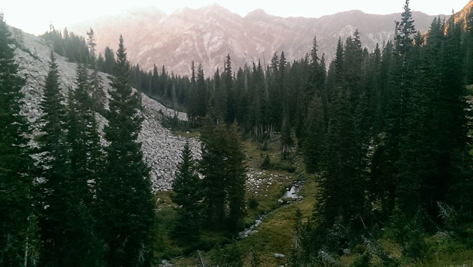 |
| Where the creek south of the lake runs along. Hard to tell from this pic, but the sunsetting on the mountains really showed the red, orange, green mountains in the distance. It was so beautiful. |
 |
| West side of the lake. Where you'll enter at. |
 |
| End of my hike, this was my light :) |
 |
| Rock wall that runs parallel to lake. This is where you can see all the deer. There were over a dozen that I counted. |
 |
| The deer next to the lake. |
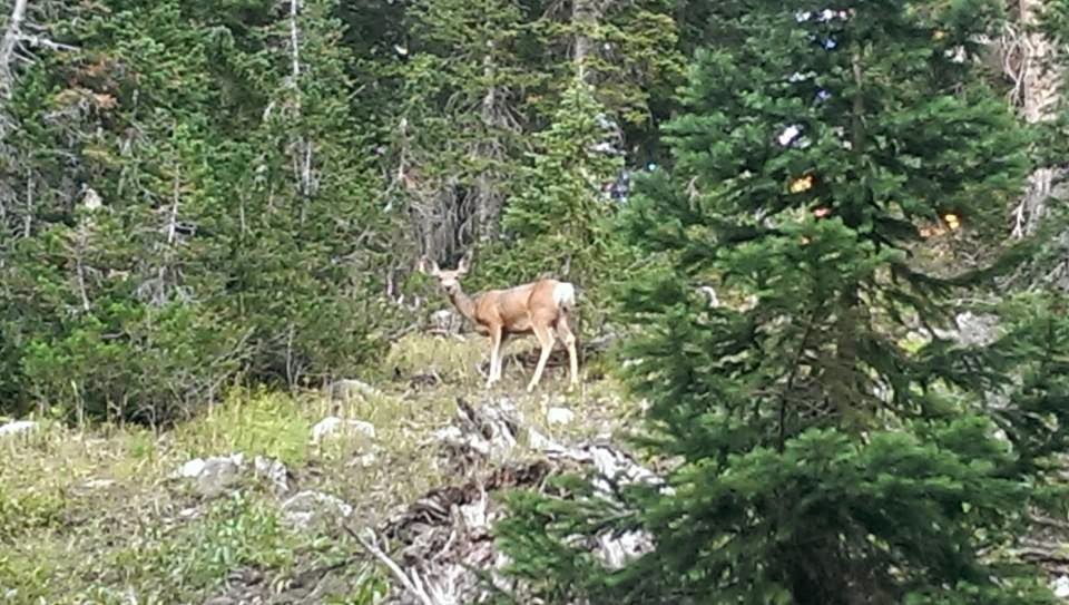 |
| Deer that scared me on the trail. Giving me the stank eye :) |
 |
| View of lower lake. Directly straight is where upper lake is. |
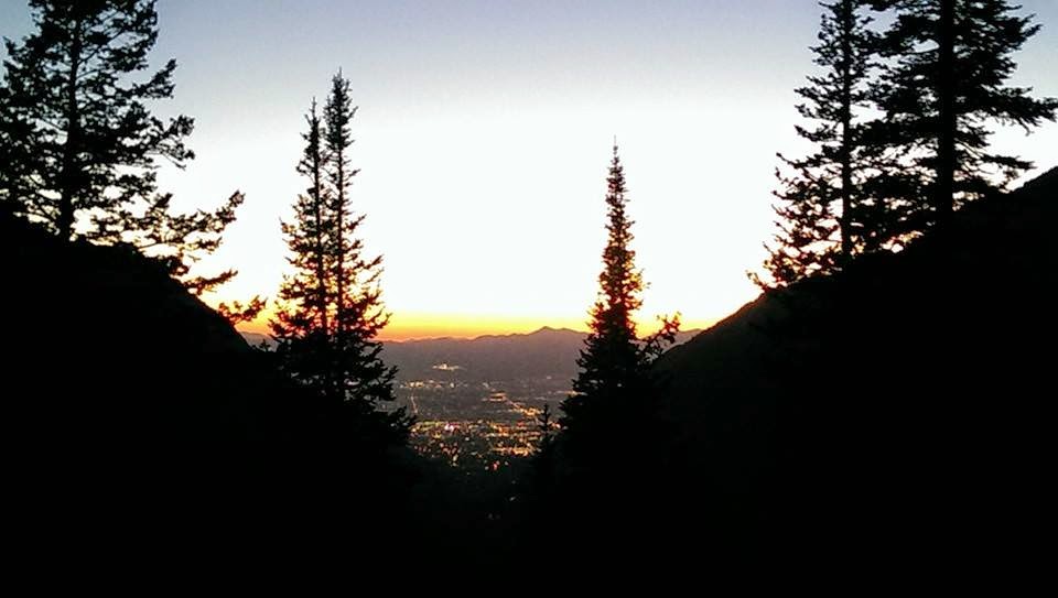 |
| The sunset over Salt Lake. So beautiful in person. |
Subscribe to:
Posts (Atom)