Wednesday, October 1, 2014

White Pine Lake- Little Cottonwood Canyon

I finally got to do my White Pine Lake hike.  This has been on my to-hike list for several months.  This attempt went much much better than the last.  There were only a handful of people along the hike.  The trail was beautiful of course.  Not too difficult for the first few miles.  I'd say moderate to low advanced.  However, around 3.5 miles (at the trailhead it says 4 miles to lake. Lies I tell you!  All lies!) I was struggling.  However, since the sign had said 4 miles, I knew I was almost there.  Nope.  Still had about 1.5 miles left.  The last half mile is very bare.  No trees to walk though.  Lots of big rocks.  Beautiful views though.  It does a little bit of switchbacks up here too.  Once you get to where you think the lake is…you still have a little ways to go.  You can actually see the lake, but then have to hike down to it.  Watch out for Marmots.  Cute…but they will steal your food so fast if given the opportunity.  These guys are a big problem at the campground on Mt. Whitney.  They're like a squirrel on serious steroids :)
When I finally got to the lake there were 2 other pairs of hikers.  Other than that though, the place is all yours.  You can walk around the lake.  If you go to the north end you can get some great lookouts to the mountains and trail.  There's a little path if you go past the north end, that you can take just to see some other views.  Go explore a little :)
By the time I got done with this hike it was a little over 10 miles.  So be prepared.  It can be steep at many parts, so walking poles might be useful for the trek down.  There are some beautiful rushing streams along the way.  You'll know the areas you can venture off the trail a little to check it out from above.  There is one stream that was small when I was there, that you had to cross, but I'm sure more wet times of year it could get a little difficult to cross and keep your tootsies dry.  Hiking in wet shoes for long durations is not ideal.  I've learned that the hard way.  Then learned again, and again, and….. :)
The trail gets warm and cold.  Towards the top it was hot because there was no shade whatsoever.  However, the rest of the drive is perfect with lots of beautiful. big trees.
I recommend this trail to those who have some endurance.  It is one of the more difficult trails due to distance and steepness.  The payoff isn't the best I've had, but it's still a great trail and worth the experience.  Go hike it while you can, because soon enough it will be piled high with snow til next July.  Be safe and enjoy the hike :)

My stats for the hike:
* 10.6 miles roundtrip
* 2,792 feet elevation gain
* 2 hour 58 min
* Advanced
* 1,247 calories (Take that gym!) 

Internet stats:
* 9 miles roundtrip
* 2,540 elevation gain
* 9,980 ft elevation at lake
* 4.5 hours
* Difficult 

From the bottom of the trail you can look across (on the other side of hwy.)
to see view of mountains.  I always try to look for the trail going up :)
Small stream along trail.
Follow the sign.  Or else you might end up on another amazing
trail.  And we wouldn't want that to happen now would we? ;) 
View from close to the top.  Less than a mile from lake. It can
get very hot during this part of the trail.  Switchbacks and no shade.
The bigger stream along trail. 
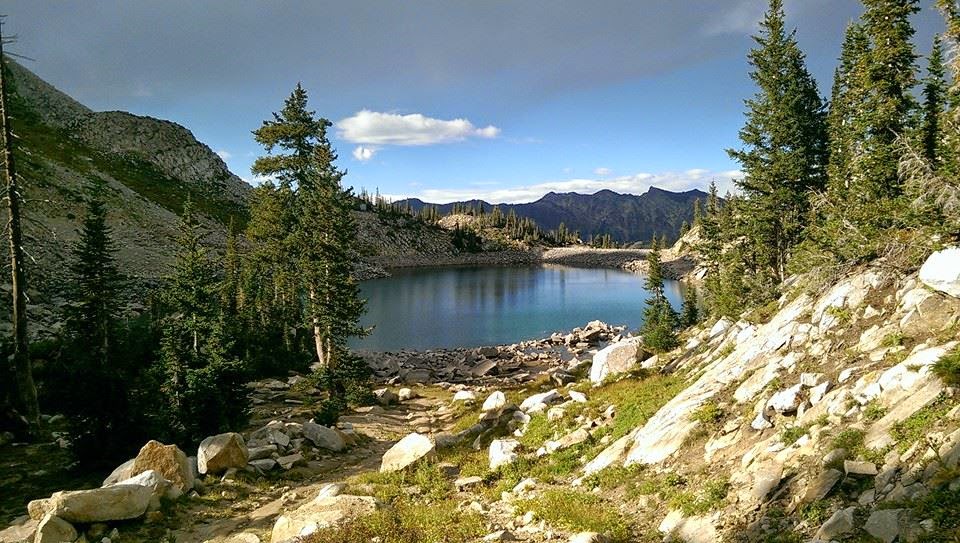
Beautiful shot of lake from north end. 

I want to go to there.  Oh wait…that's where I went :) 
View looking up before heading down to lake.  I think this
is  Pfeifferhorn.  Don't quote me on that though. 
Where the waterline at one point was.  So sad to see the
effects of the drought. 
The stream that could get not so great in wetter times of year.
View to SLC from early in the hike. 
Saw these 3 on my way down.  So many dear on the trails around here. 
The water was so clear. 
The money shot :) 
Little marmot.  He just sat there and watched me watching
him for several minutes.  We had a nice chat :)
More beautiful trail. 
Heading down the mountain.  Those mountains were covered
in fall colors.  In person was beyond picturesque 
Can't get enough pics of the beauty of the trail. 
Just one section of this beautiful trail.


Monday, September 15, 2014

New Facebook Page

I will be posting later this week about my White Pine Lake hike.  For now though, please go to my Facebook page and like it so you can get updates, new pics, hiking groups, and much more :)
https://www.facebook.com/bettisblogofhikes.
Keep checking in.  I'll post on FB when I update my blog.
Mahalo!

Thursday, September 4, 2014

Red Pine Lake-Lower

It's been waaaaaay too long since I hiked.  Almost a month.  I'd like to blame insane amounts of homework and finals for that.  After all that stress, I needed to get out.  After going to Park City Parade of Homes, I had a few hours before the sun went down…or so I thought.  I chose to go to Red Pine because White Pine was an extra couple miles and I knew I would run out of daylight.
I've been to this trail before.  I actually went to do to Red Pine, but switched to White.  This is when I first moved back here from Hawaii…and let me tell you what a shocker it was to see feet of snow instead of a trail.  The trailhead is the same for both hikes, however 1 mile up, it splits.  The first time I went the Ride Pine trail was completely covered with snow so unless you knew you where you were going, there was no way to see it.  I did about 2.5 miles in of the 4 for White.  Lost the trail deep in the mountains.  Rollin solo, so I figured better safe than sorry and turned around.
The trail looked completely different this time around.  There was actually dirt on the ground instead of tons of snow that you sink into with every step (I wore running shoes too…which are not conducive for hiking on snow).  At the mile mark where the trail splits, there's a beautiful rushing creek.  There's a bridge that goes over it.  Great spot for pics.  The trail goes up at a steady incline.  Beautiful views to the city at one point.  Theeeeennnn it starts to get a little steeper.  At first I figured I could handle it.  Slowed my pace a bit, but it was doable.  Eventually you get to a second bridge.  Do NOT go across the bridge if you want to reach the lake.  I'm not sure where the bridge goes to, buuuut one day soon I'll find out :)  Keep going on the trail.  At this point though, there's water, like a small creek, that's going down the trail.  If you have thick shoes on you'll be fine.  If you're in running shoes like mua, then you're doing some mini rock jumping.  I ran into 2 older ladies right here.  They didn't know where the bridge went to.  They were however very concerned about it being so late and I was still hiking up.  They warned me it gets steep.  Ya sure…steep like what I just did?  Oh I got this.  Boy…they weren't kidding.  It climbed awfully fast.  I had to take a couple breaks for a minute.  Even had I been more in shape, I probably still would have had to rest for a minute.  I ran into the ladies at 2.5 miles in.  The trailhead says it's 3 miles.  So I figured half a mile of this incline (less than that actually cuz it wasn't super steep the whole half mile).  Well not to burst your bubble, but it was NOT 3 miles up.  It was closer to 3.2-3.3.  I was so tired and worn out that I was getting worried I wouldn't get there.  It was getting dark.  Note to self: don't start 6.5 mile hikes at 6:30pm.  It's not summer…sun goes down earlier than 9:30 :-/  Finally I could hear water running.  I found the lake.  It was beautiful.  I wanted to walk around it, but it was getting too dark.  On the south side of it is a creek.  There's a long, short rock wall that runs parallel.  I walked along that.  Then as I was looking at the mountain in the distance, I noticed that about 100 feet away were around a dozen deer.  A couple even had the big antlers.  I had already gotten scared from one on the trail that was mere feet away from me.  I didn't notice it until it ran up the hill a little ways.  However, it stayed close and didn't run off as I passed by it.  Seeing deer is always fun.
From this point you can walk around the lake, or if you still have energy you can keep going to upper lake.  The trail for this is on the north side.  Follow that about a mile.  I'll be going back to go up there.  There was a group coming down when I was at the lake.  It seems like a popular trail.
It was getting dark, so I headed down.  It was so sad that the camera couldn't capture the amazing beauty.  The lake reflecting the mountains, the flowing creek surrounded with deer and greenery, the last of the daylight dancing on the mountain tops showing off the stunning fall colors of orange, yellow, red, and variety of greens.  I couldn't capture it, but I sure can try to describe it ;)  Going down was tricky.  Not at first.  However, the initial decent is steep so you have to take your time.  Between the cold and steepness, my knees were not happy with me (thank you arthritis).  I tried to trail run down in areas that were smoother and not so steep.  It was definitely a race with the sun.  However, the mountains were so beautiful, that you just want to stand there and watch nature.  At the 2 mile mark (that's a guestimate) you can see the valley.  All the lights were on and the sun had set, but the sky was still bright.  It was a nice scene.  Couldn't stay too long, so I headed back down.  Around the 1 mile mark there was a backpacker heading up to camp.  He's got much bigger kahunas that I, that's for sure. At this point I had to turn the flashlight on my phone.  There were too many rocks and the trees hid the moonlight.  There was a half moon that night and it was beautiful.  I'm sure a full moon night would be even more beautiful.  Finally I finished.  Right before you hit the parking lot, you cross a bridge.  I wasn't able to get pictures since it was too dark, but in daylight it's really beautiful.
I highly recommend this trail.  You can get 3 amazing hikes from here…plus there's a bathroom at the trailhead :)  To get there just keep going up little cottonwood.  It's about 5.5 miles up, then after a right curve, you'll see a regular looking parking lot (not just the dirt and rocks type) with an open gate, on the right hand side.  The trail is right behind the banos.  There's also a map here.  If you are out of shape, I don't recommend this hike, however, if you are intermediate then this is perfect.  It's challenging at times, and you need to be patient, but it's well worth the climb.  Bring your camera, because there will be great photo ops.  Who knows…maybe some deer will even photo bomb you :)

My stats for the hike:
*6.7 miles roundtrip
*2,160 feet elevation gain
*1 hour 45 min
*Moderate to Advanced
*839 calories (really?! It seems like it should've been more :-/ )

Internet stats:
*6.5 miles roundtrip
*2,040 elevation gain
*9,620 elevation at lake
*Moderate


One of the many beautiful creeks.


Some part of the trail were great for runnign

You can see the lake level has dropped

Getting a little rocky (be careful if you trail run)
This you'll see at about 2.5 miles up. 
The first bridge.  Around 1 mile up.
  

The steep incline begins…
your endurance begins to end ;) 


One of the many beautiful lookouts to even more mountains.


The bridge at 2.5 miles up.  Where
does it go???
The creek at the lake the runs by
the rock wall (south of lake).
Not so smart running down this in the dark :-/

Where the creek south of the lake runs along.  Hard to tell from this pic, but the
sunsetting on the mountains really showed the red, orange, green mountains in
the distance.  It was so beautiful. 
West side of the lake.  Where you'll enter at. 
End of my hike, this was my light :) 


Rock wall that runs parallel to lake.  This is where you can
see all the deer.  There were over a dozen that I counted. 

The deer next to the lake. 


Deer that scared me on the trail. Giving me the stank eye :) 

View of lower lake.  Directly straight is where upper lake is.

The sunset over Salt Lake.  So beautiful in person. 


Tuesday, August 5, 2014

Maggie's Peak, South Lake Tahoe

I know I know I know…I just did a Tahoe hike as my last post, buuuut this one was way more of a workout and had amazing views from up high.  I had planned on doing Tallac, but figured I shouldn't do a 10 mile intense hike before a 10 hour drive home, so I settled for a smaller one.  This trail was actually not what I was expecting.  To tell you the truth, I didn't know what to expect.  I happened to drive by a sign that said Bayview trail.  I drove past it, but then figured why not try it.  Well it actually turns into a campground (it is near Emerald Bay lookout so you will see tons of cars parked along the highway).  Drive through the campground all the way to the back.  Magically create a parking spot (as it seemed most people did) at the trailhead.  The trailhead will actually split two ways.  To the left is Cascade Falls.  Small mile and half hike to a gorgeous view and waterfall.  Great for kids.  Since I'd already done that last year, I decided to go on the other trail which was titled Desolation.  Knew nothing about it, but hey…that's part of the fun :)  It immediately starts as quite the tooshy toner.  After hiking for a short distance (although it felt like I had hiked Whitney because of the incline exhausting me and not as much shade as I would have liked) I asked some people where it went.  A lady told me Granite Lake was one mile from the start.  Shortly after that I reached it.  Small lake, quite beautiful.  Some people were swimming in it and picnicking.  However, the trail keeps going, soooo of course that meant I kept going :) I asked a couple where it went to and they said to Maggie's Peak which had a great lookout of several lakes and then loops around to Eagle Falls and back to the highway (This I believe is a 6 mile loop then walk half a mile along the highway back to the parking lot at Bayview campground).  So off I went to find this Maggie's Peak.  A ways up I ran into a large group that was enjoying the lookout (which at that point I hadn't stopped to view).  I asked where Maggie's Peak was and they said they didn't know.  I kept on then ran into another couple a little further up.  Decided to ask them as they were headed towards me.  They had gotten lost looking for it as well.  At that point the large group had caught up to us.  We all were trying to figure out where the trail was to hike up to the peak.  Alas, there was no trail that we could find, however the terrain was bare enough for us to just make our own path up (If you just look up you will see where you need to go since the other trail stays straight then soon after starts heading downhill).  Now keep in mind, if you do this hike, when you get to the first big lookout above Granite (you will be able to look out to Lake Tahoe, Emerald Bay, and Granite, then on the left if you walk over a bit you will see the canyon and Eagle Lake) this is where the trail veers up to the top of Maggie's peak.  If you stay on the main trail it will take you on the loop and you will pass Maggie's.  There are actually several small trails right at this spot, but if you go past it (like us 3 groups did) you won't see any trails going up.  Back to my story though, one of the guys in the big group had Everytrail App and was able to see that if we just went up that we would get there.  So we did.  It was at this point that I realized how grateful I was to have found them since hiking alone, especially on a trail I knew nothing about, would have led me right past this amazing view.  Going up was short, but difficult.  In less than 10 minutes I was at the top.  It had an insane lookout.  You could even see Tallac, which was the next peak over.  The group that I ended up hanging out with on the top, had done it the week before.  I saw the pictures and it was amazing.  Next year for sure :)
At the top you will climb on some giant boulders to see the view.  I counted 4 lakes in my site.  It was a clear day, so the water was bright blue.  Kinda turns your tummy a little when you look down from standing on the giant boulders, but definitely worth the lookout…just don't fall :-O  We all had some good laughs at the top and took some pictures (it was nice to get a legit pic of me and not just a selfie :) ).  Then I left them since I had to get to my journey back home (it was already 3pm and I had a looooong drive).  Going down was much easier.  There were almost too many trails down to choose.  It is very steep so if you have bad knees, I recommend walking poles on this hike.  It's always nice to get pictures on the way down since you have a better view.  There were a few spots I noticed on my way down that were great for picture taking, that I hadn't noticed on my up.  If you like climbing holders, this is a playground for you.
The trail had a decent amount of people on it, but most just went to Granite Lake.  There is camping past Maggie's, incase you want to make it a backpack trip.  Finally got back to the car.  There were no bathrooms there for me to rinse off in, so thank goodness for baby wipes :)  However, there are porta potties there incase you need them.  Cascade Falls is great if you have the energy to check it out.  That trail is a tourist trap though, but the path is pretty wide to accommodate everyone.
I was so grateful to have stumbled upon this hike.  I highly recommend it.  It was very short, but gave me a good little workout.  Bring water though as you will probably be taking a few stops to hydrate.  Bring a swimsuit if you want cuz that lake will be very inviting :)
(I only have a few pics right now, but I'll try to post more soon)

My stats:
3.5 miles total
1,750 ft elevation gain (that's in just 1.75 miles)
1 hour 7 minutes
moderate to difficult (short enough to make it moderate, but steep enough incline to make it advanced)
543 calories

Internet Stats:
3 miles total
1,900 ft. elevation gain
1-3 hours
moderate to advance level


View of Tallac from Maggie's. It kept hollering for me,
but I had to deny it my presence this time ;) 

Don't fall off the boulder.  Those of you with vertigo, I don't
recommend this ;) 

View of Granite Lake

View of Maggie's Peak from Granite.
View of Eagle Lake from the turnoff from main trail to Maggie's. 


I could only fit 3 of the 4 lakes in the one shot.  This is the main
lake, then directly below it is Cascade, then to the right I am not
actually sure and I can't find out what that lake is called. Anyone know???

Here's the shot of Lake Tahoe (and Emerald Bay), Granite (the smallest one)
and Cascade.  In person this view was breathtaking.  To the right was that other lake. 

Monday, July 28, 2014

Lake Tahoe- Emerald Bay from D.L. Bliss (Rubicon Trail)

This last weekend I was fortunate enough to venture my way over to South Lake Tahoe for some good ol' camping and hiking.  I stayed at D.L. Bliss campground which happened to have a couple trailheads at the beach parking lot.  Convenient, beautiful hikes are the best :) This was more of a walk in the park compared to the typical hiking I do, but that's just because of the lack of elevation gain.  The destination was Vikingholm at Emerald Bay.  If you've ever been to Emerald Bay, you will know what Vikingholm is.  It's a beautiful house on the bay that has unbelievable architecture.  It's state run now and they do tours.  They don't do tours of the Tea House in the middle of the bay though.  This "hike" was absolutely beautiful.  In the beginning there's a moderate incline with some stairs.  It has gorgeous lookouts of the lake and awesome boulders as well.  For the most part it's shaded but you should still wear sunscreen.  There are parts that dip down close to the water and a few "paths" that take you to the water.  The water is clear, cold, and very inviting, so bring a swimsuit incase you want to jump in. At one point of the trail it takes you to a small beach cove with lots of drift wood on the shore.  There were a few boats docked there.  At this point the trail veers away from the water and to the right.  At first I was very confused, and even disappointed that I wasn't walking next to the water anymore.  However, within a few minutes you are right back next to the water at Emerald Bay.  You will soon come to a boat/hike in only campground.  If you are fortunate enough to stay here, you will have a great view on an awesome campground.  If you are interested it's under boat in camp in Emerald Bay.  Also there's Eagle, but I believe that is closed til 2015.  Continue past the campground (watch for the Rubicon trail signs through the camp area so you stay on the trail) to get to Vikingholm.  If you'd like to continue on to Eagle Point, you can.  I believe it's a little over a mile further.  The tours of the house close at 4, so if you'd like to add that to your hike, then plan accordingly.  I started the trail at 4, so it wasn't very busy and most of the traffic had left the shore of Emerald.  There's a dock there you can jump off of, mostly covered with kids jumping off though.  There are restrooms located on the right of the house, if you need them, especially since the trail doesn't provide much privacy.

I hung out down at the bay for a while then headed back.  The trail is pretty smooth so I was able to run parts of it.  Note to self: don't eat tortilla chips and salsa an hour before a 9 mile hike…I felt a little sick the whole time which did not help me be able to run as much as I would have liked (but they were ohhh soooo gooood).  If you are a trail runner, this path is great.  Just don't trip in some areas, unless you are prepared for a cliff dive.  Speaking of which, when I first started the trail there are some lookout areas looking down.  I heard some guys yelling down below and a couple girls at the lookout laughing.  As I walked by, I looked down to see if there were guys cliff diving.  Well, I saw some guys, but they were swimming (they had just jumped off a rock into the water).  Then I thought, "hhmmmm…they have some really white swim trunks on.  And that's when I realized, they were nudey patooty! That was a good laugh to help me start my hike :D

This hike was great if you're struggling with inclines.  Don't get scared off in the beginning.  If you have any energy left on your way back, I recommend taking the lighthouse trail to the left about .3 miles from the trailhead (there will be a sign when the trail splits).  It's only .2 miles up (feels less than that) and then has a path that heads back to the parking lot going the other way.  The lighthouse isn't the best site to see, but it overlooks the lake and has some great boulders to climb on to get a better view.  This hike is more about endurance since it will be around 9+ miles roundtrip.  Don't forget to bring your camera since there will be some amazing views.  Enjoy!

My stats for the hike:
*9.1 miles total
*915 ft elevation gain
*3 hours 17 minutes (factor in time for walking around Vikingholm and checking it out)
*moderate (beginner, but due to length I think it qualifies as moderate)
*1,036 calories

Internet stats:
*9 miles
*200 feet (not sure why this is so much less than what my Strava said)
*"all day"
*beginner


Eeny meeny miny moe! 


One of the beautiful views from trail. 

You can see how clear the lake is (bottom of pic).        
Funny boulder formations
Watch your head.  This stone could
knock you out. 

Emerald Bay from boat in campground. 
               

Tea House. Ya, I'd like a "tea house" that I can
 have my servant boat me out to twice a day for some tea :-/ 
Stunning architecture
Vikingsholm (you should read the history of it)


Emerald Bay.  You can see the Tea House in the center. 

The canal that goes into Emerald from the main lake. 

The small beach cove area right before the trail curves from the lake. 


View of Lake Tahoe.  I wouldn't mind waking up to this every day :)